Spotlight: The Surrogate’s Courthouse of New York County

Surrogates Court
One the most striking buildings in the New York Commons area, the Surrogate’s Courthouse was begun in 1899. In addition to housing the Manhattan probate court it is home to the municipal archives and is therefore sometimes called the Hall of Records.

The Surrogate’s Courthouse has some of the city’s most ornately detailed interior masonry, including heavy columns that support a mezzanine that encircles a soaring atrium. Building materials include variegated colored marble, like something out of classical antiquity. Natural lighting is sparse, and late-Victorian lamp fixtures do not fully compensate. It is enough to create a pervasive gloominess throughout the building. Together, these elements set the tone of its echoing corridors, which comprise a labyrinth of beautiful but eerie spaces — so fitting for a courthouse of this jurisdiction. This building is about death and dusty records, and its architecture reflects those cold facts through darkness and weight, but it also captures the somber and transcendent role of the law in making permanent the legacies of those who are gone. To be anodyne was not a priority in 1899.

Click on the above photo to see my full album.

Spatial and Tactile Urbanism

TwoBridgesJune2016My interest in urbanism has recently shifted to absorbing its visual elements and textures. Working in Lower Manhattan has given me a chance to process the city’s massive urban fabric much more deeply. I use my lunch hours to explore, and I try to go slowly. Also, my S.O. lives in Battery Park City, so I’m often here in the evenings. Being in the city has led me to more photography and less writing. I’ve been able to absorb common law urbanism on a spatial, tactile level: walking the old blocks with their pavements of slate, cobblestone, and concrete; studying the varied architecture, from pitched-roof, colonial row houses to futuristic Art Deco skyscrapers; sitting on park benches in triangles and churchyards; touching the iron and stone and cement. It sometimes surprises me how much there still is to discover in this embryonic core of New York, and how the organic city still lives and exerts its patterns, in spite of all the modern forces that promote homogeneity.

Since I’ve had less to say lately, I’m going to start posting some of the pictures I’ve been taking, in place of frequent commentary. I will add links to Flickr albums with particular themes, and will backdate them to (roughly) when the pictures were taken. (I was hoping to embed entire albums directly into the LT page, but that turned out to be more time consuming than I can handle, given the amount of material I’d like to share. So, a cover photo that links to the Flickr album will have to do, for now). Hope my readers enjoy. And please do comment on the photos. : )

One last thing: if you have a Flickr or Yahoo account, please SIGN IN. Doing so will prevent you from having to occasionally click through distracting ads when navigating my albums. Thanks!

Land Use Imitates Art

JSRCenitEMUSqtwm

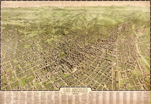
Here’s a three-dimensional, color map of Los Angeles, in 1909. It’s interesting. You can see the urban core that was beginning to take shape: the concentration of zero-lot line buildings, the canyons of concrete, the traditional green squares, the grid of warehouse blocks near the railroad tracks. Had it not been for the interruption by history — motor vehicles, modern zoning — a more traditional big city might have evolved there.

Here are a couple of surviving examples that I found of urban fabric in the core of Los Angeles, from which you could kind of envision an alternate pattern of how Southern California might have developed:

Broadway / 7th Street, Los Angeles.

Spring / West 4th Streets.

Just north of the urban core is Bunker Hill. You can see it in the bird’s-eye view, above, where the land rises behind the dense grid of streets, and the structures transition from commercial to residential. Most of what was once there is gone today. Here’s an old photograph, looking across Pershing Square:
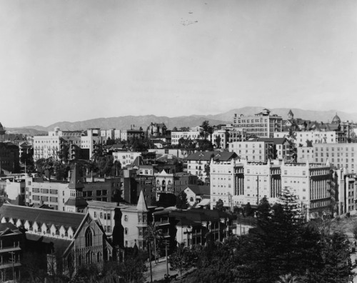
Downtown-LA-1900

Raymond Chandler described the late stages of the neighborhood’s decline in his 1942 novel, The High Window, as only he could do:

Bunker Hill is old town, lost town, shabby town, crook town. Once, very long ago, it was the choice residential district of the city, and there are still standing a few of the jigsaw Gothic mansions with wide porches and walls covered with round-end shingles and full corner bay windows with spindle turrets. They are all rooming houses now, their parquetry floors are scratched and worn through the once glossy finish and the wide sweeping staircases are dark with time and with cheap varnish laid on over generations of dirt. In the tall rooms haggard landladies bicker with shifty tenants. On the wide cool front porches, reaching their cracked shoes into the sun, and staring at nothing, sit the old men with faces like lost battles.

In and around the old houses there are flyblown restaurants and Italian fruit stands and cheap apartment houses and little candy stores where you can buy even nastier things than their candy. And there are ratty hotels where nobody except people named Smith and Jones sign the register and where the night clerk is half watchdog and half pander.

Out of the apartment houses come women who should be young but have faces like stale beer; men with pulled-down hats and quick eyes that look the street over behind the cupped hand that shields the match flame; worn intellectuals with cigarette coughs and no money in the bank; fly cops with granite faces and unwavering eyes; cokies and coke peddlers; people who look like nothing in particular and know it, and once in a while even men that actually go to work. But they come out early, when the wide cracked sidewalks are empty and still have dew on them.

The urban fabric of Bunker Hill was almost completely demolished in the 1960s under a massive redevelopment plan. For a sense of what was lost: George Mann, a Los Angeles photographer, took this picture in 1959:

4653171282_5f2d7f67fb_o

Grand Avenue / 2nd Street. Photo by George Mann, courtesy of Dianne Woods and the George Mann Archives. (Fair use.)

Update: The Lost Public Baths of New York City

IMG_3278A few years ago, I wrote a short piece about the lost public baths of New York City. Built around the turn of the 20th century, the public baths were meant to address the lack of sufficient bathing facilities in areas with (1) high concentrations of old-law tenements and (2) no public beaches. They were concentrated on the east side of Manhattan.

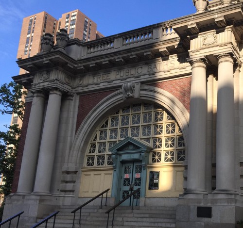
This summer, I came across one of the bath buildings that still remains. Here’s a picture that I took on July 4th of the Free Public Baths at 23rd Street and the East River, which has now been converted into a public swimming pool. Still, the original inscription remains on the architrave:

FREE PUBLIC BATHS | CITY OF NEW YORK

The mix of tenements that once characterized the area — and which gave rise to the public baths — is long gone. The adjacent super-blocks are now occupied Peter Cooper Village (a formerly middle-income housing development) and the VA Hospital.

Here’s the structure, and its context, on Street View: